
LANDSCAPE URBANISM
The city is the result of natural, historical, cultural, geological, economic, social, political and other phenomena. There is not a single concept for the city. Taking into account the existing environment (natural or artificial) is a type of material and cultural resistance against the development of generic and inhuman railway stations North and East of Paris, with various schemes for the preparation of sustainable strategies capable of offer a range of new architectural typology.
The sector Gare du Nord/Gare de l'Est is representative of the intersection of these ecologies generating a highly complex socio-geographical environment: abandoned railways, national and international flows of people, residual spaces, home to middle class, etc., representing a multimodal crossroads of flows where coexist TGV, Eurostar, Transilien, RER, subway, bus, taxi and Vélib '.
It may be noted various spatial conflicts:
- No link exists between Gare du Nord and Gare de l'Est, while the 2 stations are within 200 meters. - The North Station is by far the most complex of the French rail network, with the presence of many jumps separations allowing the reclassification of the tracks. -> create multiple divisions
- Many spaces are lost along the railways, which were built after the industrial age, leaving many residual spaces or abandoned warehouses.
- The space taken in the territory by rail creates a huge barrier to each side of the tracks, creating fractures, and a discontinuity on the ground.
The units, which were completed before 1949, represent 66% of all dwellings. Moreover, compared to urban, many homes are insecure (16% of homes in this area are called discomfort, or are still devoid of toilets or indoor shower.). The mayor of Paris, is no longer able to maintain and solve these problems. Compared to this area, there is a very small percentage of green space, with only about twenty public gardens, a dozen green areas, and some parks, but still very small and represents only 0.4 square meter of green space per person.
The infrastructure network of Paris is completely isolated, unrelated to the neighborhood that houses it, especially with the problem of the matching between different network types is very difficult. This analysis will serve me later in the programming of urban generated, thereby defining public spaces feature the use of existing spaces, but we can see a huge concentration of people in the two stations, without cuts, which softened away stations.
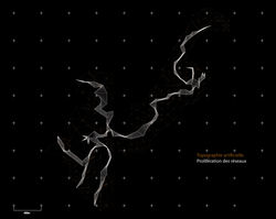
This is the first point of design. This shows the level of connectivity based on geographic location. This simulation allowed me to leave some routes in the territory of the station, with various degrees of intelligence. Nevertheless, I have thus observed with this simulation that the railways are only spaces for space division, leading to various societal problems (poverty, crime ...). My second point of the design was done with the study of noise pollution of the site, then I could model in 3D with a Z factor. On the other hand, I generate with maps of different connectivities and strategic points of the site a mesh of physical barriers on the site.
So here is the beginning of the result of my early studies, with the merging of different meshes. Making physical negotiations between the different meshes, so I was able to generate a prior artificial topography, which is the beginning of my design quite unconventional. At this stage there, I started to take an architectural and urban planning position. For this, I initially made a physical model to realize to a different way the architectural possibilities and the form finding. I started thinking about landscaping, giving me various kinds, depending on the extraction of certain attractor lines. Thus, we can observe different spatial conditions in my mesh, such as valleys, ditches, trays, bowls...
From there, I started to retrieve rows, trying to deliver a masterplan. The network connectivity, from a complex process by interpolating the lines, have begun to create a fracture in my mesh, showing an exploitable potentially way. As these networks have different intensification connectivities, and inform early decisions for the rest of the project. In relation to this rupture, it is interesting to see how locally, it generates micro-systems, which will enable the new space, and an early program reflection. Here is the first draft of a masterplan, offering the boundaries between flows and infrastructure. Here emerge different areas creating a pattern of plots and paths. From there, territorial strategies have been developed with green areas, housing areas, equipment areas, activities areas, and various flows of people (walking ...) Thus at the level of connectivity and networks (transport, energy networks, intangible networks and infrastructure networks).
This new production and construction of formal processes in the city is based from the selection of certain parameters dictated by the city, with his theories and his community, including attendance at places, lack of connectivity, lack of public spaces, etc.. In this way, the proposal creates an urban landscape that can function as a thick tectonic system and network to help make the borders disappear in town.
 |
|---|
 |
 |
 |
 |
 |
 |
 |
 |
 |
 |
 |
 |
 |
 |
 |
 |
 |
 |
 |
 |
 |
 |
 |
 |
 |
 |